
 Austrian bioenergy group Cycleenergy acquired controlling interest in Greenpower Projektentwicklungs GmbH, expanding its biomass operational portfolio by 16 MW to a total of 22 MW. In the transaction Cycleenergy took over 51% of the company and thereby formed a joint venture with Porr Infrastruktur GmbH, a subsidiary of Austrian construction company Porr AG. Greenpower operates two wood chip CHP facilities in Upper and Lower Austria, each with an electric capacity of 2 MW. The plants have been in operation since the middle of last year and consume more than 30,000 tonnes of wood chips and are expected to generate over €5 million in additional revenue.

WMO: La Niña conditions strengthen, expected to continue

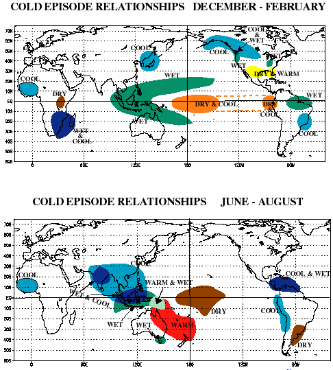 The event has already influenced climate patterns over the last six months across many parts of the globe, including in the direct vicinity of the equatorial Pacific, as well as more widely, across the Indian Ocean, Asia, Africa, and the Americas. Many economic sectors - from mining and forestry to agriculture, bioenergy, fisheries and transport - can be affected by La Niña. During cold La Niña episodes the normal patterns of tropical precipitation and atmospheric circulation become disrupted (map, click to enlarge).
La Niña conditions, which started in the third quarter of 2007, continue across the central and eastern Equatorial Pacific, the WMO says. Basin-wide features are now typical of the mature stage of a La Niña event, including in the western Equatorial Pacific. The magnitude of the event continues to be in the middle range of those observed in the historical record.
The La Niña event is expected to continue at least through the first quarter of 2008. Many La Niña events in the historical record are found to decay rapidly during the March-May period, but it cannot be determined at this time whether or not this event will decay during the same period. By the middle of the year, La Niña and, what is referred to as ‘neutral conditions’ are considered to be about equally likely, with El Niño continuing to have a low likelihood of occurrence at this stage. Long-term statistics indicate neutral conditions should currently be considered a more likely outcome for the latter part of 2008.
Over the last three months, La Niña conditions have matured and become slightly stronger. Sea surface temperatures are now about 1.5 to 2 degrees Celsius colder than average over large parts of the central and eastern Equatorial Pacific. The local atmosphere is strongly coupled to this SST situation, with trade winds strengthened and cloudiness reduced in central and eastern equatorial Pacific region. However, in the far eastern equatorial Pacific near South America, the La Niña conditions are not as strong in the last few weeks.
In 2007, when the La Niña became established, conditions in the western equatorial Pacific, were initially not typical of a La Niña, but over the last three months, they have also become generally consistent with a La Niña event, and sea surface temperatures surrounding northern Australia and into much of the Equatorial western Pacific are about 0.5 degrees Celsius warmer than normal. Basin-wide conditions are therefore now reflecting a La Niña pattern.
There is good agreement amongst forecast models and amongst expert interpretations that the current event is well established and should continue at least through the first quarter of 2008. There is more uncertainty over conditions for the second quarter of the year. However, a rapid decay of the event during March-May, while still possible, is not considered likely, given the current strength of the prevailing ocean sub-surface and atmospheric patterns that are reinforcing La Niña.
Most models indicate a more gradual decay that starts early in the year, but still leaves substantial coolness in the central and eastern Equatorial Pacific during the second quarter of the year. Thus, most interpretations suggest that the likelihood of La Niña conditions remains heightened through the second quarter and, at a lower level of confidence, into the first part of the third quarter of 2008. Some models suggest that it is possible that a temporary weakening of the event may begin in the next few weeks, associated with a temporary reversal of atmospheric conditions, but this is not expected by model interpretations to lead to a substantial rapid decay of the event:
 energy :: sustainability :: biofuels :: biomass :: bioenergy :: agriculture :: forestry :: mining :: climate :: El Niño :: La Niña ::
 At this time, longer-lead seasonal forecasts for time periods beyond the third quarter of 2008 are not considered to contain useful information on the occurrence of La Niña or El Niño. It should be noted that very rarely, a La Niña event will persist for two years or slightly longer, such as occurred from early 1998 to early 2000. However, the likelihood of such a situation developing in this case will remain unclear for some months to come, but will be closely monitored. At this point of time, based on long-term statistics, neutral conditions should be considered a more likely outcome for the latter part of 2008.
This La Niña continues to be in the middle range of La Niña events found in the historical record, although the slight further cooling in the central and eastern equatorial Pacific in the last couple of months will likely place it on the stronger side of the middle range. The event has already influenced climate patterns over the last six months across many parts of the globe, including in the direct vicinity of the equatorial Pacific, as well as more widely, across the Indian Ocean, Asia, Africa, and the Americas.
Users and decision makers in areas with a tendency for anomalous climate patterns during such events should be aware of the expected continued presence of La Niña, but should also continue to recognise that other factors influence seasonal climatic patterns as well. They are therefore encouraged to consult the climate forecasts for their location and consider the appropriate risk management strategies.
The above observations illustrate the need for detailed regional assessment of prevailing conditions and combining expected El Niño/La Niña influences with influences from other geographic regions, to anticipate likely weather patterns regionally and locally over the coming months. Locally applicable information should be consulted in detailed national/regional seasonal climate outlooks, such as those produced by National Meteorological and Hydrological Services (NMHSs) and Regional Climate Outlook Forums (RCOFs).
The situation in the equatorial Pacific will continue to be carefully monitored. More detailed interpretations of regional climate fluctuations will be generated routinely by the climate forecasting community over the coming months and will be made available through National Meteorological and Hydrological Services.
El Niño/La Niña Background
Climate Patterns in the Pacific
Research conducted over recent decades has shed considerable light on the important role played by interactions between the atmosphere and ocean in the tropical belt of the Pacific Ocean in altering global weather and climate patterns. During El Niño events, for example, sea temperatures at the surface in the central and eastern tropical Pacific Ocean become substantially higher than normal.
In contrast, during La Niña events, the sea surface temperatures in these regions become lower than normal. These temperature changes are strongly linked to major climate fluctuations around the globe and, once initiated, such events can last for 12 months or more. The strong El Niño event of 1997-1998 was followed by a prolonged La Niña phase that extended from mid-1998 to early 2001. El Niño/La Niña events change the likelihood of particular climate patterns around the globe, but the outcomes of each event are never exactly the same.
Furthermore, while there is generally a relationship between the global impacts of an El Niño/La Niña event and its intensity, there is always potential for an event to generate serious impacts in some regions irrespective of its intensity.
Forecasting and Monitoring the El Niño/La Niña Phenomenon
The forecasting of Pacific Ocean developments is undertaken in a number of ways. Complex dynamical models project the evolution of the tropical Pacific Ocean from its currently observed state. Statistical forecast models can also capture some of the precursors of such developments. Expert analysis of the current situation adds further value, especially in interpreting the implications of the evolving situation below the ocean surface. All forecast methods try to incorporate the effects of ocean-atmosphere interactions within the climate system.
The meteorological and oceanographic data that allow El Niño and La Niña episodes to be monitored and forecast are drawn from national and international observing systems. The exchange and processing of the data are carried out under programmes coordinated by the World Meteorological Organization.
Map 1: Current La Niña event. Credit: WMO.
Map 2: During cold La Niña episodes the normal patterns of tropical precipitation and atmospheric circulation become disrupted. Credit: NOAA.
References:
WMO: La Niña Conditions Strengthen, Expected to Continue - February 11, 2008.
WMO: La Niña Update - detailed [*.doc] - February 11, 2008.
posted by Biopact team at 6:32 PM
![]()
![]()


1 Comments:
Useful summary. Thank you.
Post a Comment
Links to this post:
Create a Link
<< Home